Software
I build and maintain research software that includes new algorithms, modeling frameworks, and reproducible pipelines. Some projects develop novel methods (RivGraph, VotE), some are end-to-end modeling efforts (e.g., DeepReservoir for RL-based reservoir operations and Pydro for differentiable runoff + routing); some are data-wranglers (dapper, satval, hillsloper). Across all of them, I turn messy, “big”, multi-source environmental data into analysis-ready products and model-ready inputs. I’m big on reproducibility and automation—especially when it lets us ask new questions and see the world like we never have before.
I began coding during my PhD studies with Matlab, and later picked up Python when I started my postdoc. This is also when I found my passion for creating software through the development of RivGraph. Since then, I’ve branched into other languages and richer Python. Almost all of my packages have a geospatial component, and I frequently integrate Google Earth Engine. With the exception of Pydro, I was the primary developer for each package listed here, but many friends and collaborators have contributed ideas, knowledge, and code.
DeepReservoir
(under development)
DeepReservoir is a deep reinforcement learning framework for optimizing reservoir operations in a virtual hydropower-reservoir environment. It supports building scenario-driven environments (rules, constraints, objectives) and training policies with modern RL libraries, enabling rapid experimentation with alternative operational strategies.
- Repository: actively being developed; currently private. Contact me if interested.
- Tech: deep reinforcement learning (stable-baselines3), simulation environments
- Language(s): Python
Pydro
(under development)
Pydro is a differentiable runoff + routing modeling effort designed for hybrid physics/AI learning. The goal is to make hydrologic modeling components trainable end-to-end, while still retaining physically meaningful structure. Work to date includes development of a global wildfire–hydrology dataset (unreleased) for training and validation.
- Repo: email me
- Tech: differentiable modeling
- Language(s): Python
VotE (Veins of the Earth)
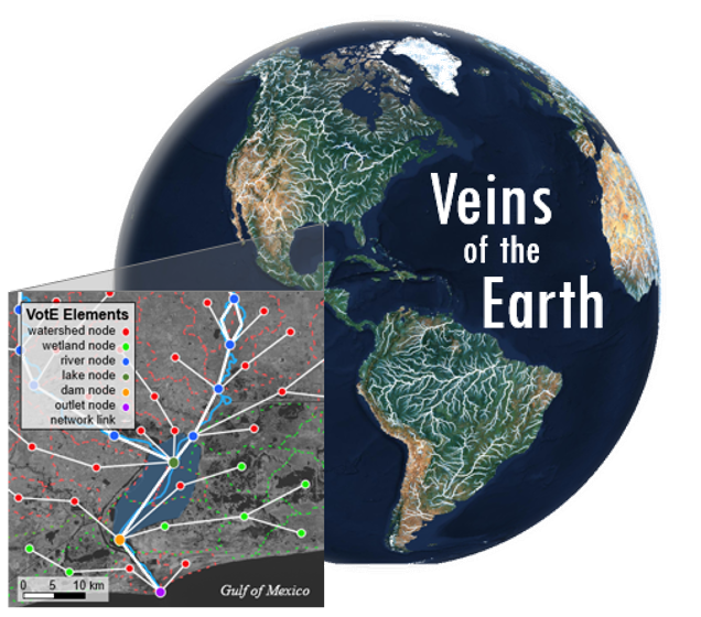
It’s hard to fully explain what VotE is. One on hand, it’s just a database with a user-friendly API. On the other, it’s a first-cut towards an ambitious vision to fuse global hydrologic data into a common, AI-ready platform that’s in the direction of a “digital twin” (or “Hydrotwin” as I’ve pitched the idea a few times). It’s given us a glimpse into the power of data fusion, the opportunities that still remain, and the ways it can let us re-imagine the questions we can ask about the Hydrosphere.
More concretely, VotE is a river-centric data platform and API for rapid querying, model building, and visualization across global river networks. It is designed around an AI-ready geospatial schema and workflows for integrating river-network–based datasets (e.g., hydrography, dams, attributes) into a consistent, queryable system for analysis and data-driven modeling.
The repository itself includes scripts to build VotE as well as the API (but not the data + database itself). It’s somewhat messy; we are slowly bringing it toward something publicly releasable. Reach out if you’re keen to see it!
- Repo: email me
- Tech: PostgreSQL, PostGIS, geospatial data modeling, data fusion techniques
- Pubs: Poster
- Language(s): Python; SQL
dapper (Data PreParation for ELM Runs) is a toolset for curating, sampling, and formatting the datasets needed to run DOE’s E3SM Land Model (ELM). It automates end-to-end data preparation workflows (meteorological forcings, parameters, and related inputs), leaning on Google Earth Engine and other APIs to make sampling fast, scalable, and flexible for different grid-cell definitions (e.g., polygons like watersheds rather than rectangular grids).
- Repo: GitHub
- Tech: Google Earth Engine (GEE), netCDF/xarray-style workflows, geospatial sampling
- Language(s): Python
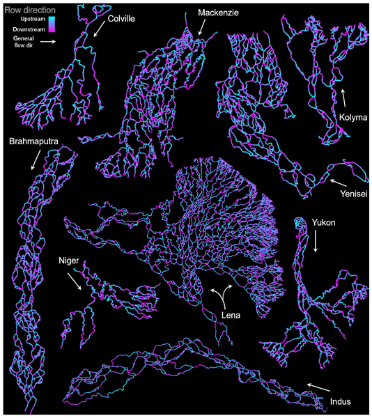
RivGraph is a Python package that extracts river and delta channel network topology (nodes/links) from georeferenced binary mask rasters. It automatically assigns link directionality and computes a range of topologic and morphologic network metrics, supporting reproducible studies of braided rivers and deltas.
- Repo: GitHub
- Pubs: JOSS · ESurf Dynamics
- Tech: image processing, graph analysis, geospatial I/O
- Language(s): Python
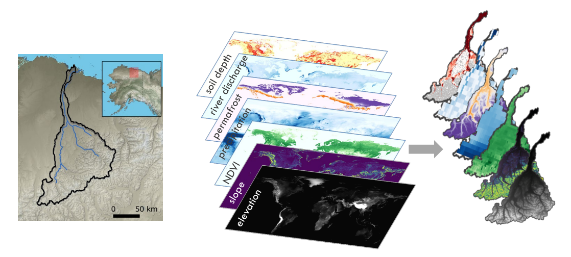
rabpro (River and Basin Profiler) delineates watershed basins and computes river profiles, slopes, and related longitudinal metrics at global scale. It can also compute contributing-basin statistics for arbitrary raster inputs (e.g., topography, precipitation, vegetation) via Google Earth Engine, providing a flexible bridge between user-defined locations and basin-scale context.
- Repo: GitHub
- Pubs: JOSS
- Tech: Google Earth Engine (GEE), watershed delineation, raster statistics
- Language(s): Python
RivMAP
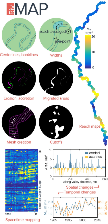
RivMAP (River Morphodynamics from Analysis of Planforms) is a Matlab toolbox for extracting planform river morphodynamics from binary channel masks. It quantifies centerlines and banklines, width, migration rates, and cutoff events, and was built to support large-scale Landsat-based mapping of river planform change.
- Repo: GitHub
- Pubs: Earth and Space Science
- Tech: river planform analysis, image processing, Landsat workflows
- Language(s): Matlab
Ecopopper
Ecopopper generates flexible, unstructured “ecopop units” to help bridge scale mismatches between Earth System Model grids and local ecological / population dynamics models. It supports coupling workflows and scenario experiments that need spatial units more meaningful than coarse model grid cells.
Ecopopper was part of a large LANL team’s effort that resulted in two R&D100 Awards in 2025.
- Repo: GitHub
- Tech: spatial clustering/typologies, scale-bridging units, ecology/hydrology
- Language(s): Python
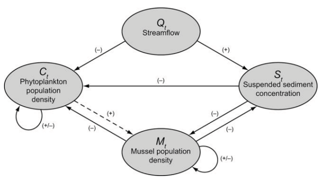
RiverMUSE
RiverMUSE simulates freshwater mussel population dynamics under changing suspended sediment and flow regimes, supporting scenario experiments that connect hydrology/sediment forcing to ecological response at reach scale. The model itself was a collaboration among coauthors; I merely coded it.
- Repo: CSDMS
- Pubs: Freshwater Science
- Tech: ecohydrology, scenario simulation
- Language(s): Matlab
hillsloper
hillsloper partitions DEMs into constituent hillslopes for high-resolution terrestrial simulations. It extracts a connected river network and maintains hillslope–channel connectivity, making it easier to build modeling domains that respect drainage structure and terrain controls.
- Repo: available upon request
- Tech: DEM analysis, terrain partitioning, hydrologic connectivity
- Language(s): Python
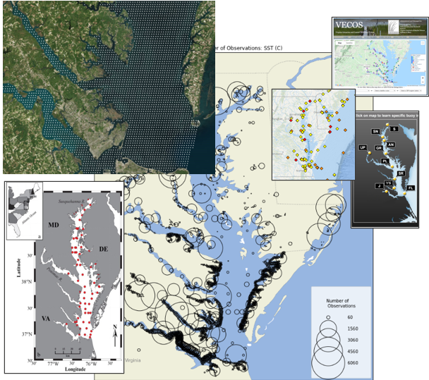
satval
satval samples multispectral satellite pixel features aligned in space and time with in-situ water-quality observations. It supports satellite–field validation and modeling by aggregating observations within shared pixel footprints and assembling analysis-ready matched datasets.
- Repo: available upon request
- Tech: Google Earth Engine (GEE), remote sensing validation, water quality
- Pubs: Journal of Applied Remote Sensing
- Language(s): Python